

Conservation & Biodiversity
The most comprehensive data substrate for the greatest environmental challenges.
Real conservation begins with real data
At ArborMeta, we firmly believe you can't manage what you can't measure. Through terrestrial LiDAR scanning, we're revolutionising the way forest data is captured, processed and acted upon. Our mission is to provide the most accurate data for the causes that need it most.
Monitoring biodiversity from the ground up.
Terrestrial LiDAR scanning allows vegetation and natural environments to be digitally modelled with extremely high precision.
We've innovated the systems and software to bring this cutting edge technology to the world of biodiversity monitoring and conservation, starting from the ground up. Each tree, rock, riverbed and overhang can be assessed and analysed in detail.


Geo-Located Stem Detection
Measuring vegetation with Terrestrial Laser Scanners allows each tree's stem location to be accurately identified and linked to a geo-located waypoint. This information can be exported to standard GIS mapping software and linked to other metrics for each tree.


Hover to interact. Geolocated stem detection within a sample TLS vegetation plot.
Touch to interact. Geolocated stem detection within a sample TLS vegetation plot.
Advanced Canopy Mapping
Using proprietary modelling software, we map canopy extent for each tree within a survey plot. This information is used to inform further investigations regarding vegetation growth and extent.

Hover to interact. Geolocated canopy mapping within a sample TLS vegetation plot.
Touch to interact. Calibrated canopy modelling between TLS plot (centre) and larger ALS Swathe.

Cutting edge data, hand tailored to your project.
Our dedicated team of software engineers and data scientists are experienced in extracting key metrics from each Terrestrial LiDAR Scan. This enables us to tailor the data to perfectly meet the needs of your conservation project.

Other Services
Learn more about the other services we provide.

Ecological Capture
For complex natural environments.

Long-Term Monitoring
For the duration of your project.

Fire Assessment
Assessing the impact of fire.

General Survey
For efficiently capturing key metrics.

Growth Analysis
Assessing changes in vegetation.
Ecological Services
We offer a range of services for applying Terrestrial Laser Scanning (TLS) to conservation causes. Each service can be tailored to perfectly suite specific project targets, reporting guidelines and other requirements.
General Survey
ArborMeta can perform general TLS vegetation surveys to capture data on a range of informative metrics, including woody volume, DBH, biomass, stem density, height, stem location, surface area, canopy volume and area, tree architecture & more.
We tailor our data collation and delivery to your needs.

Long-Term Monitoring
Want any or all of the above services, over an extended timeframe? We know that many conservation projects require extensive monitoring requirements.
We offer long-term monitoring options so that you can benefit from our modern analytical techniques well into the future.
Ecological Capture
By generating a digital twin of a forest structure in incredible detail, we capture data of high ecological importance. Through post-analysis of a digital twin, we are able to assess the presence of nesting hollows, determine the scale of die-back and much more.
Fire Assessment
In order to assess the effects of wildfires and prescribed burning, it is crucial to have ecological data you can rely on. By utilising TLS before and after fires, we assess change in vegetation density, canopy cover, understory and more.
This data can be compared to our extensive database of terrestrial LiDAR scans, which covers more than 70 Australian bioregions.
Detect growth with millimeter detail
By performing replicate terrestrial LiDAR scan surveys at annual intervals, we measure changes in vegetation structure and mass over time with unprecedented detail.
Using the geo-located point cloud of each tree, change can be measured and assessed at each survey interval. This allows for efficient and reliable project monitoring, on a tree-by-tree basis.
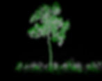

Touch to interact. Two scans of an identical tree are shown, each taken one year apart. Grey points show tree in Year One, while green show tree in Year 2, illustrating growth in leaves, trunk and surrounding vegetation.
Hover to interact. Two scans of an identical tree are shown, each taken one year apart. Grey points show tree in Year One, while green show tree in Year 2, illustrating growth in leaves, trunk and surrounding vegetation.

Have other ideas? Contact us today
| © ArborMeta Pty Ltd 2024 |